Wildfire Information
Oregon experiences wildfires year-round, with peak activity in late summer and fall.
In the event of a wildfire situation in Columbia County, this page will be updated regularly with the latest emergency information in Columbia County.
Find links to the latest on wildfires, tips to build a Go Kit, learn about evacuation levels and a sign up for alerts on smoke and evacuations in your area at Public Alerts.
Oregon’s Department of Forestry (ODF) and the Oregon State Fire Marshal maintain real-time fire situation maps showing active large fires, evacuation zones, and hotspots Oregon Office of State Fire Marshal. The Oregon Live Wildfire Tracker and Frontline Wildfire Defense map update every 15 minutes, displaying fire perimeters, incident names, and evacuation notices projects. You can view these maps to see if fires are near your area and to check for evacuation orders or smoke advisories.
Evacuations and closures in Columbia County
There are no current evacuations or closures in Columbia County.
Oregon Department of Emergency Management (OEM) View a map of evacuation areas and active fires in Oregon
Check road closures on Trip Check
Evacuation sites in Columbia County
Columbia County Fairgrounds
58892 Saulser Road, St. Helens, Oregon 97051
503-397-4231
Other Resources:
Evacuations and closures in neighboring counties
Multnomah County None.
Clackamas County None.
Washington County None.
Additional Resources:
Red Cross Safe and Well - After a disaster, letting your family and friends know that you are safe and well can bring your loved one's great peace of mind. This website is designed to help make that communication easier.
If people are seeking a motel/hotel and think they are experiencing price gouging, they can report it to the Oregon Department of Justice or call 503-378-8442.
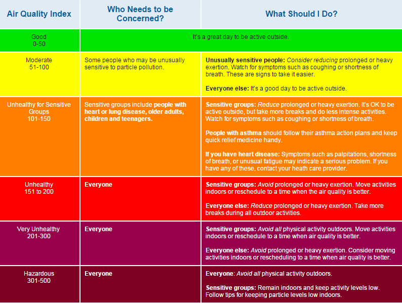
Air quality hazards in Columbia County
For real time data on air quality in your neighborhood, check out the links below.
Track air quality and fire status
Oregon Smoke Blog Local, state, tribal and federal organizations coordinate to share information about wildfires and smoke.
Oregon Air Quality map The Department of Environmental Quality updates a map of current air quality. Due to high traffic, the site can slow or crash. The sites below offer good alternatives.
EPA Air Quality map The Federal Environmental Protection Agency pulls real-time air quality data from Oregon and Washington States.
State of Oregon Fires Map The Oregon Office of Emergency Management updates a map of active fires, air quality and closures.
Washington State Fires Map The Washington State Emergency Operations Center updates a real-time map of fires and air quality.
Washington State Air Quality Map The state’s Department of Ecology maintains a real-time map of air quality.
Air quality and health: